The Walks
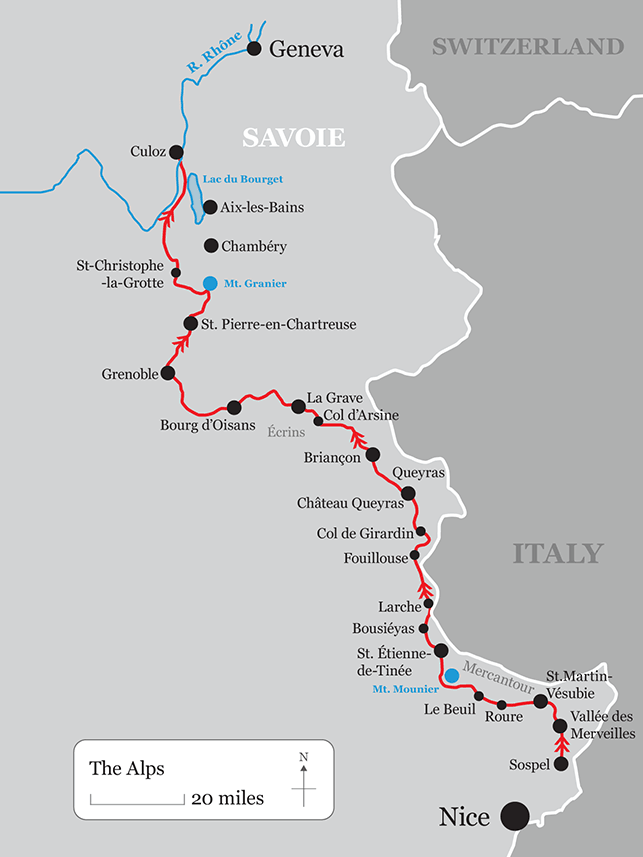
Alps
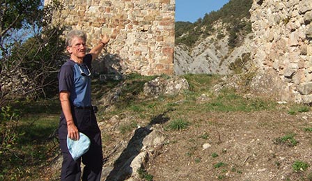
Photo: Terry and Deserted Village
The region
All the way up the Alpine trail I saw the Italian influence in the decoration of buildings-houses painted pink, yellow, terracotta, sea green and peach; grand doorways, sculpted figures and cherubs in Briancon; Italian baroque in the churches. In Roure the west front of the church with its classical pilasters and peeling paint looked like a stage set for an Italian movie.
Everywhere I found the remains of old fortifications from the Middle Ages, from the reign of Louis XIV with Vauban's forts at Chateau Queyras and Briancon, from the First and Second World Wars.
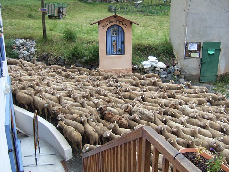
Cattle produce milk, butter and cheese from the Alpine pastures and there are still large flocks of sheep and goats. I saw flocks on the move, a little like the transhumance of old, with the whistling of shepherds, the barking of dogs and the ringing of bells. If you do not like cheese, bacon and cream, then do not visit the Alps!
Forests cover many mountain sides, particularly in the Isere, but they are facing hard times because the costs of recovering wood are high.
There is plenty of evidence of depopulation of Alpine villages.
Men went to extraordinary lengths to make the mountain slopes suitable for crops by digging long irrigation channels. Desperation to feed a growing population caused land hunger. This is the only explanation for such extraordinary engineering. The peasants also built terraces which had to be maintained by dragging soil uphill every year.
To escape from the tough life of the old days families emigrated as far afield as Mexico.
In the Alpes Maritimes the valleys are narrow and deep and the scree fragile and prone to landslips. It was as if I could see the erosion happening before my eyes.
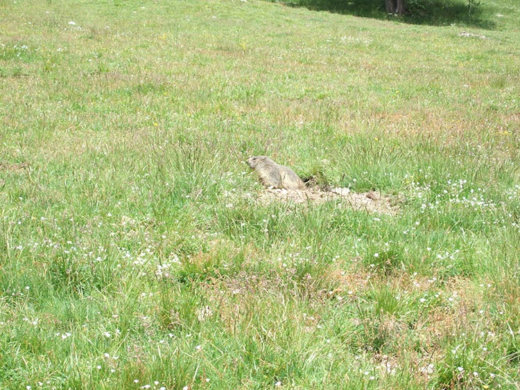
The most evocative sound is the high pitched shriek of marmots waddling to their holes to escape a bird of prey. They are endearing with their button eyes, long whiskers and fat tails.
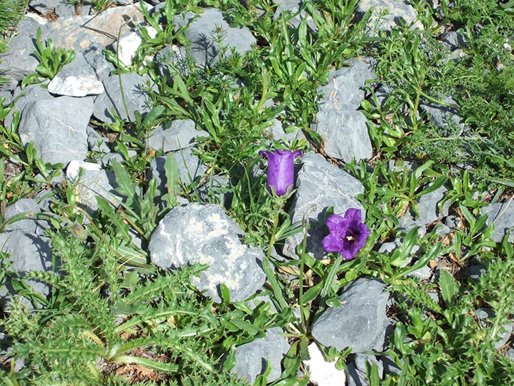
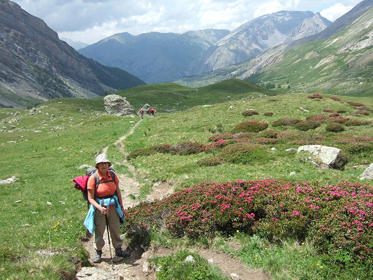
An astonishing variety of flowers decorate unrelenting slopes of grey shale in June - brilliant yellow helianthemums, small white daisies and irridescent blue gentians.
Some high mountain valleys are like a Garden of Eden when the flowers are in full bloom - white anemones, pink rhododendrons, sinuous purple geraniums, orange daisies and pink delphiniums among graceful larch trees.
The Ecrins is an outlying Alpine massif north west of Briancon - black granitic mountains less fragile than their eastern neighbours but equally demanding to climb.
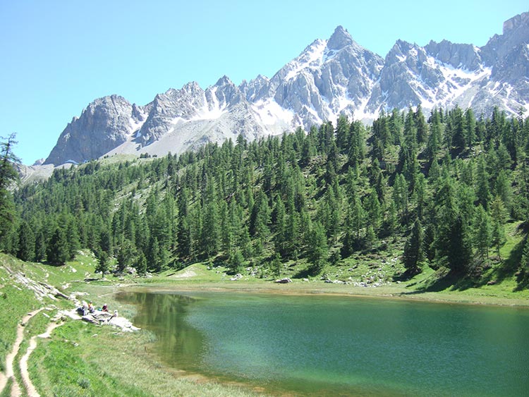
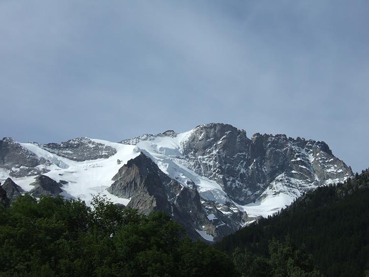
The Meiji, 3,983 metres, in the Ecrins has hanging ice falls with massive seracs. It is quite clear that the glaciers have receded in recent years leaving their former path exposed in the summer months.
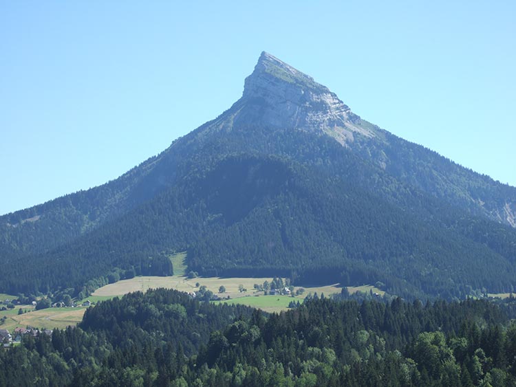
Grenoble sits in a great bowl surrounded by mountains. To the north are the Jurassic walls of the Chartreuse, to the west the limestone wilderness of the Vercors and to the south the Ecrins.
The best view of the city is from the Bastille fortress on top of a mountain rising straight up from the River Isere's ice blue waters.The red and ochre roofs of the old city directly below hug the left bank of the river in a tight semi-circle. The population has grown from 23,000 in 1821 to 469,000 today. Concrete towers, the pipes of chemical works, the Winter Olympics village from 1968 and the distinctive annulus of the Syncotron nuclear research facility cover the valley floor and reach up to the mountain walls. On a hot day a heat haze, a cocktail of urban pollution for which Grenoble is well known, covers everything.
The old buildings in the narrow winding streets have been restored and crowds throng the open air cafes and markets. The novelist Stendhal is promoted as the city's favourite son but he hated the place.
The Chartreuse, a region of limestone peaks and plateaus, is one of the most unusual landscapes in France - multiple fissures and holes in the rocks, deep chasms and sheer cliffs, bone dry pastures, peaks eroded into strange shapes like amputated limbs.
Back to top
Diary extracts
Around Mount Mounier
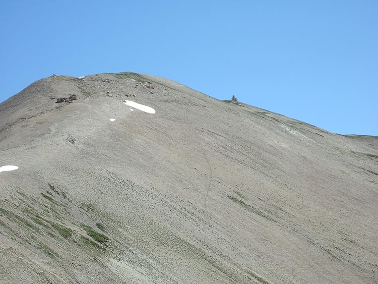
In the distance dark pinnacles of rock pierced the clouds. I came over a rise in the ground and there was a plateau with the GR5 winding its way towards a ridge and the Col de Crousette. The mountain slopes had been scoured clean of vegetation. Large white clouds started to boil up the rocky cliffs to my left and surge over the ridge I had to cross. The last thousand feet of Mount Mounier were completely submerged in thick mist. Dropping down over the ridge I faced a difficult traverse across steeply sloping slabs of black rock in very poor visibility. The slope to my left looked fierce but I has no means of knowing how far it went or exacly where the Col was. Creeping along slowly on the slippery ground I eased my way past a hollow of snow. With the help of a compass I reached the Col only to be assaulted by a gale and a torrent of rain. Now the challenge was to keep my feet while descending the couloir of shale to the north. The rock here was almost jet black with grains of quartz. The boulders cascaded down from Mounier, as big as houses.
Below the clouds an enclosed valley spread before me with great rock walls sweeping up both sides. Brilliant green grass covered the floor and a lazy stream flowed from a motionless black tarn. It would not have surprised me to see a nomad's tent pitched on its banks, until I remembered this was France and not Central Asia.
I slipped and tripped the whole way down in the mist. The mountain slopes reduced the valley floor to a mere crack for the stream. Under a pall of cloud it looked as if I was entering a tunnel. The river started to plunge towards a gorge and suddenly I found myself on a rocky ledge where one false step would have been fatal. As I stepped over a gap with a void between my legs I could hear the roar of a waterfall below.
A rustic gite
In practice there was only one place to stay in Bousieyas, the gite d'etape described in the Topoguide as offering confort sommaire, summary comforts. The dormitory consisted of one room with eight narrow bunks on the lower level and eight on top; stone floor, stone walls and a very narrow corridor for everyone to pile their luggage - in short a small cattle shed. A French acquaintance later ironically described the gite as folklorique, which might translate as rustic. Three strong Dutch women decided they preferred their tent in a field. In the end thirteen of us slept there that night. Every time I turned over I hit my neighbour in the face. However the variety of characters was fascinating. First of all I met a mountain guide called Joel and his wife from Digne-les-Bains. He started to worry me when he described the approach to the Pas de Cavale from the north. This was on my route the next day. "There are a number of neves running across a 40 degree slope including one which I found hard and very slippery at 9.30am. I crossed it by fixing a rope." I thought this was all a bit beyond me until I met John, aged 78, and his friend Brian, a mere 71. With the Englishman's gift for understatement John said "Don't worry about the snow. Just keep looking ahead, lean on your poles and shuffle across; you'll be fine! Oh and watch the scree this side of the Pas; quite tricky." Later Joel reassured me that later in the day the snow would be softer and easier. If I fell I would probably survive and just break a leg! John was incredibly fit for his age. This was his second trip on the GR5. 20 miles a day; 4,000 feet of up and down; no problem! In recent years he had done the GR10 across the Pyrenees, again with Brian. How had he found it? "It was OK but the sleeping was a bit rough in the Ariege; some of those shepherd's cabanes you know!" "What was wrong with them?" "When you wake up and see a rat's eyes looking at you, you feel a bit uneasy!"
The Chartreuse
The going became more difficult. A number of holes opened up in the rocks and I had to start hopping from one to another. Would my legs hold out? The next descent was longer than expected and another big cliff loomed ahead. What goes down must also go up-law number one in the mountains. The ascent was particularly taxing. The path started up a canyon with large boulders barring the way. I tried to get into a rhythm - haul myself up a rock cursing at the weight of my rucksack, have a rest and then make another effort. But worse was yet to come! I turned left up a crack in the canyon's side and the gradient got even steeper. As I pulled myself up over each rock step I could only see sky between my legs. I was pointing on my toes and hopeing my calf muscles were up to the task.
I was now in another wide Alpine pasture. It was 5.15pm and I had at least an hour's walk to reach a col before making a steep descent to the gite d'etape. Would I be there in time for supper and when could I get a drink of water? These were the only issues that mattered. I reached the col at 6.15pm and slumped to the ground to drain the last drop of water from my flask. I could have durnk a gallon. Rubble and the occasioanl rock covered the path which fell away through the trees. The descent took fifty minutes and I made the gite just after 7pm having left Saint Pierre at 9am. When I reached the gite I immediately asked for water and downed three large tankards. Jumping into a hot shower was nothing short of ecstatic.
Savoy
On the borders of Savoie I came across some of the pride which Savoyards feel in being different from other Frenchmen. Savoie was united with France one hundred and fifty years ago but the feeling of distinctness has not died out. Laurent told me an amusing story about the insular inhabitants of Seyssel in the Rhone valley. The town spreads out on both banks and is therefore partly in Savoie and partly in the Ain. When the inhabitants in the Savoyard half cross the river they say "Now we are in France" as if Savoie was not French!
Back to top
The Walk
View more details.
In the course of a month in the Alps I climbed 66,000 feet and descended a roughly equivalent distance. I followed the GR52 from Sospel to Saint Dalmas-Valdeblore, with a diversion from the Vallee des Merveilles over the Pas de l'Arpette to the Gordalasque valley and Saint Martin Vesubie. Thereafter I used the GR5 transalpine trail all the way to Briancon with some local footpath diversions to find accommodation. The GR5 is one of the most heavily walked trails in Europe but most walkers tackle it north to south. It starts in Holland and runs all the way down the Alps, crossing the valleys running east to west.
At Briancon I left the GR5 and took the GR50 to Le Monetier-les-Bains to join the GR54 Tour de L'Oisans as far as Le Bourg d'Oisans.From here I continued on the GR50 to Ornon, a section which is not much used. I lost the infrequent way marks on a steep section and had to scramble down some rocks in a narrow strip of forest between two cliffs. Take care! I continued on the GR50 to the ski resort Alpe du Grand Serre and from there used local footpaths and the GR549 to reach Vizille on the southern edges of Grenoble.
North of the city I joined the GR9 at the Bastille and followed it to Le Sappey-en-Chartreuse. From here I followed local footpaths over the Col de Port to the monastery of the Grande Chartreuse and later St. Pierre-de-Chartreuse. I ascended a local path east of St. Pierre to rejoin the GR9. This runs on a dry limestone plateau with no water sources for a long way-take plenty of liquid with you. I descended to easier country at La Plagne and continued on the GR9 to the edge of the Chartreuse at St. Christophe-sur-Guiers. There are many sudden cliffs and chasms in the Chartreuse. Take care at all times. Apart from a compass amd good maps I found a GPS invaluable in this region.
Distance is less significant in the Alps than the amount of climbing and the difficulty of the descents. While I did not have to do much scrambling the walking is tough. This is definitely not a stroll in the park-be prepared. It took me 30 days from Sospel to the Chartreuse, not pushing myself too hard, and the distance is approximately 360 miles.
Back to top
Maps and Guides
Sospel to St. Dalmas-Valdeblore: Topoguide GR5-52 Tinee-Vesubie, Vallee des Merveilles Ref. 507. FFRP. IGN 1;25.000 maps 3741ET; 3741OT.
St. Dalmas-Valdeblore to Briancon: Topoguide Ref. 507. IGN 1:25.000 maps 3641ET, 3640OT. Topoguide Ubaye/Pays du Viso Ref. 635. FFRP. IGN 1;25.000 maps 3537ET, 3536OT.
Briancon to Grenoble: IGN 1:25.ooo map 3536OT. Topoguide GR54 Tour de L'Oisans Ref. 508. FFRP. IGN 1:25.000 maps 3336ET, 3336OT, 3335OT
Chartreuse: IGN 1;25.000 maps 3334OT, 3333OT
Back to top
Weather
Obviously many of these trails are covered in snow and ice between October and May. Some cols are even covered in June. On the other hand it can be very hot in high summer and walkers are advised to take plenty of water and sun protection. Read the Practical Advice section of this web site.
Back to top
Accommodation
I list below places where I stayed which I can particularly recommend. I have not covered every stopping place on my route. Some refuges and gites d'etapes are busy in the high season so it is worth booking in advance.
Auberge Provencale
Route du Col de Castillon
06380 Sospel
Tel. 00 33 (0)4 93 04 00 31
fax 00 33 (0)4 93 04 24 54
http://www.aubergeprovencale.fr
Le Relais du Camp d'Argent
06440 Turini
Tel. 00 33 (0)4 93 91 57 58
Fax 00 33 (0)4 93 91 58 08
Le Relais des Merveilles-Gite d'Etape
Route de la Gordalasque
06450 Belvedere
Tel. 00 33 (0)4 93 03 43 55
Fax 00 33 (0)4 93 03 93 33
http://www.relaisdesmerveilles.com
Auberge Le Robur
Rue Centrale
06420 Roure
Tel. 00 33 (0)4 93 02 03 57
Fax 00 33 (0)4 93 02 03 58
Gite d'Etape Ma Vieille Ecole
Roya
06660 St. Etienne de Tinee
Tel. 00 33 (0)4 93 03 43 05
Gite d'Etape Les Granges Chez Bourillon
Fouillouse
04530 St Paul sur Ubaye
Tel/Fax 00 33 (0)4 92 84 31 16
Gite-Auberge Les Baladins
05600 Ceillac
Tel. 00 33 (0)4 92 45 00 23
Fax 00 33 (0)4 92 45 22 31
http://www.baladins.queyras.com
Gite d'Etape Les Astragales
Ville-Vieille
Tel. 00 33 (0)4 92 46 70 82
Fax 00 33 (0)4 92 46 86 13
http://www.les-astragales.queyras.com
Chambres d'hotes-Mme. N Moya
38 rue du Melezin
Villard-St-Pancrace
05100 Briancon
Tel. 00 33 (0)4 92 20 58 68
Gite Le Flourou
31 rue Bonbourget
05220 Le Monetier-les-Bains
Tel. 00 33 (0)4 92 24 41 13
http://gites05.free.fr/gites/flourou
Gite la Breche
Rue du Serre du Grou
05480 Villar d'Arene
Tel. 00 33 (0)4 76 79 92 06
Hotel des Skieurs
38700 Le Sappey-en-Chartreuse
Tel. 00 33 (0)4 76 88 82 76
Fax 00 33 (0)4 76 88 85 76
La Ferme Bonne de la Grotte
73360 St. Christophe la Grotte
Tel. 00 33 (0)4 79 36 59 05
Fax 00 33 (0)4 79 36 59 31
Back to top
Photographs
Click on the thumbnails below to see larger images with captions.